| N23°53.93 E97°37.40 |
Off Topic: Locating Loiwing airstrip(s), Yunnan, China Page 2 of 6: Loiwing Factory airstrip |
Route NA |
| Text | Notes |
|
In November 1938, Gordon Seagrave recorded the arrival of CAMCO advance man, Dan Gourley, and then CAMCO plant manager, "Chuck" Hunter: "The company [CAMCO] sent me from Haiphong to Rangoon by plane," he [Dan Gourley] said. "The manager of the factory, Mr Hunter is trying to come through from Kunming by car over the Burma Road. . . I want . . . to have a satisfactory site picked out for the factory before he arrives. . . ." I spread out the map and showed him my choice, as well as two other plateaus, much smaller, but closer to the Burma border. . . . "Your first suggestion is a perfect spot," said he, "but it is too far from that little spur of the Burma Road. I have selected the two other sites. They are within a quarter mile of the border and we will have no trouble transporting our supplies." . . . Mr Gourley returned to Rangoon. . . . one day, a station wagon . . . drew up . . . A thick‑set, muscular man stepped out. It was Mr "Chuck" Hunter, manager of [CAMCO]. He had come down the Burma Road from Kunming as far as the Salween River and then, one day's journey by car from his goal, had had to turn back[14] to Kunming and come to Burma by air. . . . he went across the river to Pang Kham, the English bungalow nearest the chosen site at Loiwing, and set up headquarters in a grass shack. Though their headquarters were so close to us, they were busy and we were busy and we did not see much of each other.[15] Allied intel provided its own introductory material for the Factory strip in Airfield Report No 21:[17]
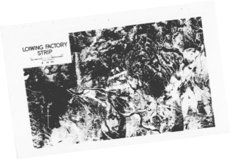
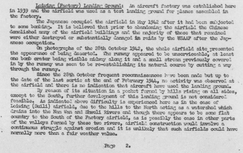
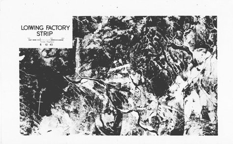
Transcription: Loiwing (Factory) Landing Ground: An aircraft factory was established here in 1939 and the airfield was used as a test landing ground for planes assembled in the factory. The Japanese occupied the airfield in May 1942 after it had been subjected to some bombing. It is believed that prior to abandoning the airfield the Chinese demolished many of the airfield buildings and the majority of those that remained were either destroyed or substantially damaged in raids by the USAAF after the Japanese occupation. On photographs of the 28th October 1942, the whole airfield site presented the appearance of being deserted. The runway appeared to be unserviceable, at least one bomb crater being visible midway along it and a small stream previously covered in by the runway was seen to be reestablishing its natural course by cutting a way through the runway. Since the 28th October frequent reconnaissances have been made but up to the date of the last sortie at the end of February 1944, no activity was observed at the airfield and there is no indication that aircraft have used the landing ground. By reason of its situation in a pocket formed by hills rising on all sides, except to the south, further development of this landing ground is not considered feasible. As indicated above difficulty is experienced here as in the case of Loiwing (Suili) airfield, due to the hills to the north acting as a watershed which drains into the Nam Wan and Shweli Rivers and though there appears to be some flat country to the south of the Factory airfield, as is possibly the case in other parts of the valleys formed by these two rivers, airfield construction would involve a continuous struggle against erosion and it is unlikely that such airfields could have normally more than a fair weather value. The concern expressed in the last paragraph of the Allied intel report about surrounding terrain is similar to that in Matt Poole's evaluation 70 years later.[17a] The implied criticism in the report should be directed at the Allies who developed the sites, rather than the Japanese who merely "acquired" them in place. This is the Loiwing Factory Strip, aka CAMCO airstrip, built in 1939, reconstructed after being bombed by the Japanese in October 1940, and then sabotaged by CAMCO employees in the face of its imminent takeover by the invading Japanese in May 1942:[17b]
High resolution image is available here. And a text description of Loiwing (Factory):[18]
Higher resolution image available here. Transcription:
• "Coordinates": for runway midpoint are N23°53.93 E97°37.40. Additionally:
• The north arrow on the aerial photo was found to be only
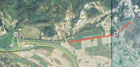
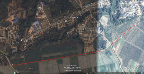
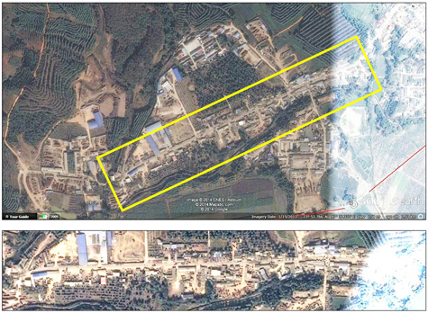
I roughly located the area on Google Earth (GE) and copied the resulting screen image with Gadwin PrintScreen. I found some prominent features common to both GE and the 1943 aerial photo and marked them on the GE image, white circles at two intersections & red lines on two roads, using Microsoft Publisher:[20]
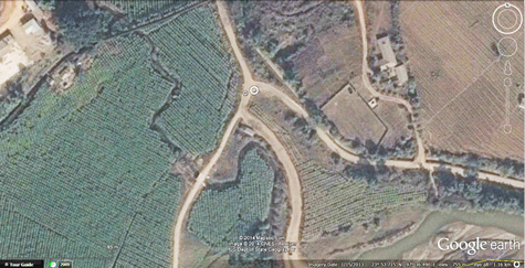
High resolution image available here. Closeup of an intersection near the SW corner of the image, marked with a white circle:[21]
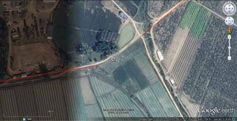
High resolution image available here. The reference point near the east border of the image --- the intersection of tangents of roadway centerlines. The GE view straddles a seam joining two satellite photos not adequately adjusted for differences in quality:[22]
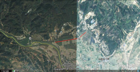
High resolution image available here. The two roads associated with this east reference point, traced in red, viewed from a greater altitude:[23]
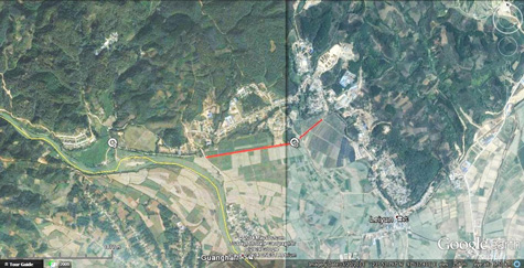
High resolution image available here. And the area from yet a greater altitude:[24]
I found the difference in quality between the two sides of the seam to be sufficiently distracting that I tried to minimize it: Older photos in GE's Historical Imagery option only found even more darkness. I could have used that --- it would have produced a uniform appearance which I could have then enhanced by modifying brightness, contrast, gamma. But sometimes different editions in GE's Historical Imagery don't match well; what I had in hand did, so I used what I had. I divided the image into two with IrfanView, using the stitch line as the division, and improved contrast and brightness in each individually, using IrfanView. When the two separate images approximately matched each other, I rejoined them, using Microsoft Publisher. The result was hardly perfect, but at least I could see ground details clearly in the entire composite image:[25]
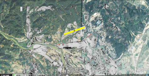
High resolution image available here. I input the resulting image into a layer of a PhotoShop worksheet (leaving background blank). I copied a small section of the 1943 black and white aerial photo covering key features of the airstrip, saved it as a GIF, and put that into a separate layer of PhotoShop. There I deleted unessential details in the photo; ie, most of the black, leaving shades of gray to define the photo details: I did this by selecting them using the 'magic wand' and hitting the delete key. Because of the special characteristics of a GIF image, the areas from which detail had been deleted were left as transparent 'holes'. And with the detail that I could see through the holes in the GE image in the next layer, I was able to size and align the aerial photo to the GE image. I saved the PhotoShop file and then saved an image of its combined layers. I put that image into Microsoft Publisher, where I measured in the recorded airstrip length of 940 yards (860m) using the GE scale; however, it didn't fit, so I put in an 800m line instead, and checked its heading (~06/24):[26]
High resolution image available here. Then I went back to GE and, using the details in the composite image, defined the location of the center of the runway: N23°53.92 E97°37.40. The current situation in more detail:[27]
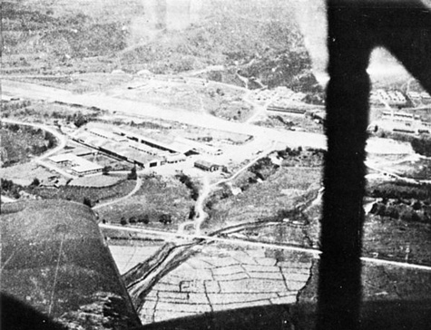
High resolution image available here. Compare the 1943 aerial photos above with this oblique photo of the CAMCO Loiwing facility taken while the field was under Allied control from an aircraft cockpit and looking roughly NNW:[27a]
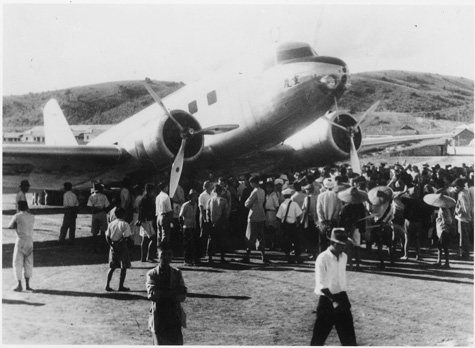
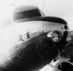
Plus this on-the-ground view looking roughly ESE across the runway with CAMCO facilities in the background:[27b]
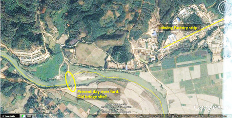
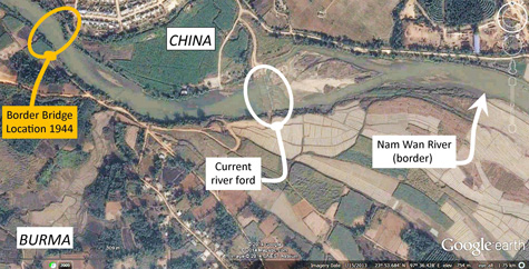
The bridge which Dunford Wood and later Olga Greenlaw crossed to go from Burma to China --- over the Nam Wan --- no longer exists. Information on its location was not initially available. Using the Airfield Report No 21 aerial photo of the Factory site, I originally proposed this location as a possible site of the now missing border bridge:[28]
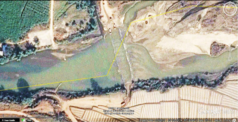
High resolution image available here. At location N23°53.610 E97°36.525, there is a ford through the Nam Wan (river). That the ford might be located at the site of the former bridge has a certain appeal to logic:[30]
High resolution image available here.
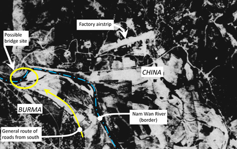
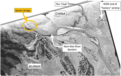
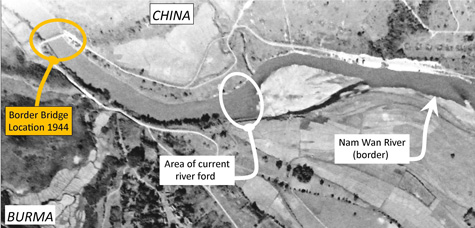
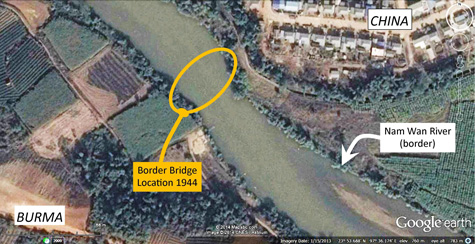
However, a 1944 aerial photo of the area, found by Matt Poole wading through NARA records, extended farther to the west and shows clearly that the site I suggested was not in use, but that a bridge --- the bridge, approximately 40m, probably a single span --- did exist about 700m upstream at N23°53.7 E97°36.2:[31]
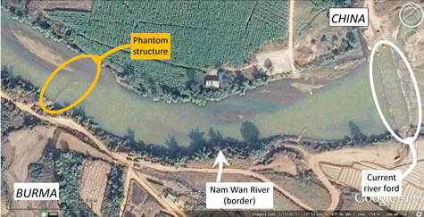
The general area as viewed via Google Earth:[33]
However, the location of the phantom image on a current Google Earth view does not coincide with that of the bridge on the NARA 1944 aerial photo. So the wreckage of the border bridge must be assumed to have been salvaged sometime after the date of the ground-based photo of the same bridge in January 1945. The origin of the phantom structure is not known.
|
14.^ Turning back at the Salween suggests that the bridge was not functional sometime shortly after the date noted by Seagrave: November 1938 (BS, p 94). However, Seagrave had traveled this road and described using the suspension bridge in early 1937 on a trip to Kunming (BS, p 100); date per Basil Mathews, Flaming milestone: being an interpretation and the official report of the twenty-first world's conference of the World's Alliance of Y.M.C.A.'s, held in January 1937, in Mysore, South India (Geneva CH: Worlds Committee of YMCAs, 1937). The Burma Road had been completed in 1938, and Seagrave recalled having "seen the huge iron sections of that bridge carried up over the Burma Road --- before it was a car road at all."(BS, p 100) Where Hunter finally landed in Burma is not clear. 15.^ Seagrave, Gordon, Burma Surgeon (New York: Norton, 1943), pp 95-96. 16. (deleted) 17.^ Airfield Report No 21, April 1944, p 2 (USAF Archive microfilm roll A8055, p 0628). Enhanced with IrfanView by author.
17a.^ Matt Poole email of 1119 hrs 01 Nov 2014. For example, see note on hill location.
17b.^ Airfield Report No 21, April 1944, photo date 08 Oct 1943, following numbered p 6 (USAF Archive microfilm roll A8055, p 0634). Enhanced with IrfanView by author.
18.^ Airfield Report No 21, April 1944, p 6 (USAF Archive microfilm roll A8055, p 0633). Enhanced with IrfanView by author.
19.^ Coordinates and realignment per Google Earth. Airfield Report No 21, April 1944, photo date 08 Oct 1943, following numbered p 6 (USAF Archive microfilm roll A8055, p 0634). Image tilted counter-clockwise and enhanced using IrfanView, by author.
20.^ Excerpt from Google Earth view of N23°53.76 E97°37.10. Images captured with Gadwin PrintScreen, either side of vertical stitchline separately enhanced with IrfanView; images rejoined and annotated using Microsoft Publisher, by author.
21.^ Google Earth view of N23°57.73 E97°36.49 at eye alt 1.16km. Image captured with Gadwin PrintScreen, enhanced with IrfanView and annotated with Microsoft Publisher by author.
22.^ Google Earth view of N23°53.75 E97°37.64 at eye alt 1.16km. Image captured with Gadwin PrintScreen. Annotation by author using Microsoft Publisher (note the variation in Google Earth image quality on either side of the vertical stitchline without IrfanView-based enhancement here and in the two images immediately following).
23.^ Google Earth view of N23°53.77 E97°37.40 at eye alt 2.14km. Image captured with Gadwin PrintScreen. Annotation by author using Microsoft Publisher.
24.^ Google Earth view of N23°53.74 E97°37.40. Image captured with Gadwin PrintScreen. Annotation by author using Microsoft Publisher.
25.^ Google Earth view of N23°53.79 E97°37.44 at eye alt 5.51km. Image captured with Gadwin PrintScreen. Images either side of vertical stitchline separately enhanced with IrfanView by author. Images rejoined and annotated by author using Microsoft Publisher.
26.^ Google Earth view of N23°53.79 E97°37.44 at eye alt 5.51km. Underlying Google Earth image per note 25 above. Overlay by author using Adobe PrintShop. Annotation by author using Microsoft Publisher. Matt Poole corrected me: he found the 940 yard runway length did fit within present day features (email of 0153 hrs 02 Nov 2014).
27.^ Google Earth view of N23°53.90 E97°37.38 at eye alt 5.51km. Image captured with Gadwin PrintScreen. Whole image enhanced with IrfanView, but without compensating the right side where detail is not particularly relevant. Annotation by author using Microsoft Publisher, with extract beneath from Google Earth view using IrfanView.
27a.^ Attributed to "Smithsonian", and appearing in Stanley, Roy M, Col, Prelude to Pearl Harbor (New York: Scribner's, 1982), p 183 (photo undated). Enhanced with IrfanView by author.
27b.^ The image has a somewhat misleading title: Loiwing: a new link in China National Airways. CNAC seemed to fly on demand to various locations dictated by military need as Japanese land forces advanced north from Rangoon; so "new" CNAC destinations came to include Lashio and Myitkyina, amongst others, per Olga Greenlaw (ibid); by Apr 1942, CNAC aircraft were flying "the Hump" under Allied contract transporting war materiel from India to China. Image enhanced with IrfanView by author. The DC-2's CNAC name, painted on its nose, is 庆重 or Chungking / Chongqing (the city, with characters read right to left):
per Xu Ying (Lieuwe Montsma email of 2024 15 Feb 2015). Of possible tangential interest, the aircraft had previously carried the name, Kweilin, and as such had been history's first civilian passenger aircraft to have been forced down by a hostile military aircraft and strafed on the ground with 14 killed on 24 Aug 1938 (see Kweilin Incident). Following the attack, it was retrieved, rebuilt, and renamed Chungking. On 29 Oct 1940, it was again strafed on the ground, this time at Changyi Airport, and destroyed, with nine fatalities (see Kweilin restored as Chungking). A review of dates relevant to the name of the CNAC aircraft Chungking is here. 28.^ Airfield Report No 21, April 1944, photo date 08 Oct 1943, following numbered p 6 (USAF Archive microfilm roll A8055, p 0634). Enhanced with IrfanView and annotated using Microsoft Publisher, by author. 29.^ Google Earth view of present day ford across Nam Wan, N23°53.610 E97°36.525. Image captured with Gadwin PrintScreen, enhanced with IrfanView and annotated using Microsoft Publisher, by author.
30.^ Google Earth, ibid. Lieuwe Montsma points out that there are currently two more fords downstream, per Google Earth, of uncertain vintage (N23°53.12 E97°37.27 and N23°93 E97°37.54), plus two bridges: a modern two lane bridge (N23°53.02 E97°37.98) and an older one lane bridge (N23°51.59 E97°38.62), all before the Nam Wan joins the Shweli at N23°50.76 E97°38.67 (attachment to Montsma email of 09 Jan 2015 1520). Image captured with Gadwin PrintScreen and enhanced with IrfanView by author.
31.^ Part of image dated 29 Jan 1944, provided by Matt Poole from NARA records (image MP9353 per email of 0653 hrs 09 Dec 2014). Image tilted so that north is up-page, extracted, and enhanced, using IrfanView; and annotated, with Poole's advice, by author using Microsoft Publisher. Coordinates as fitted to Google Earth (image repeated from page 1). For additional information on the bridge, see photo in Nov 1944 with discussion.
32.^ Image, extracted (further) from that described in Note 31. Enhanced using IrfanView, annotated using Microsoft Publisher, by author.
33.^ Google Earth view. Image captured with Gadwin PrintScreen, enhanced with IrfanView and annotated using Microsoft Publisher, by author.
34.^ Google Earth view. Image captured with Gadwin PrintScreen, enhanced with IrfanView and annotated using Microsoft Publisher, by author.
35.^ Google Earth view. Image captured with Gadwin PrintScreen, enhanced with IrfanView and annotated using Microsoft Publisher, by author. |
-descrip-Feb-44.jpg)